

Whether it’s a rare book printing found at long last or piece of ephemera found in an archival collection by chance, those who visit the University of Houston Special Collections almost always find something they cannot wait to share with others. Here we celebrate what makes the University of Houston Special Collections so special–our Favorite Things.
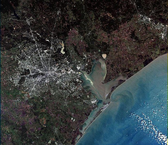
The satellite view is spectacular and confirms what we already know—Houston is big. At last count, Houston’s incorporated area covers about 667 square miles. We know this because the City of Houston Planning & Development Department has created an informative slide show that illustrates the city’s ever-changing boundaries. “Annexations in Houston or How we grew to 667 square miles in 175 years” can be found online.
If you want to research urban planning in Houston the old-fashioned way—using text and images printed on paper—try the Special Collections Department at UH Libraries. I recommend the old-fashioned way because, while it is not as convenient as surfing the web, it is way more fun.
Discoveries abound in Special Collections. Every folder holds a surprise. My most recent discovery was a set of maps from the Paddock Greater Houston Convention & Visitors Council Records. As the name suggests, this collection contains records collected by Marianita Paddock from her years with the Greater Houston Convention & Visitors Council. But it also includes maps of cities and counties in Texas from the mid-twentieth century. Some of the maps are common but others are unusual, such as a 1948 Ashburn’s Map of Houston in a special edition issued for Forest Park cemetery on Lawndale.
The most significant is the City of Houston’s Zoning District Map, December 15, 1947. Houston was small once, and I don’t mean when the Allen Brothers founded it in 1836. As late as the 1940s, it was a compact city of 75 square miles. This map reminds us that in 1947 the city’s boundaries extended no farther than Kirby Drive on the west, Brays Bayou on the southwest, and Sims Bayou on the southeast. The Heights, Rice Institute, and the new Texas Medical Center were on the edge of town.
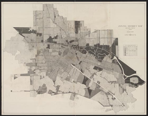
City of Houston, Zoning District Map, December 15, 1947, Paddock Greater Houston Convention & Visitors Council Records
The map is a historical footnote to the larger question of urban planning in Houston. Most people know that Houston is the largest city in the country without land use zoning. So why was the city publishing a zoning map? The answer is that it was done to educate citizens about the issues in the upcoming special election in January 1948 when they would be asked to approve a new law authorizing zoning. It’s no spoiler to say that voters rejected the law. Progressives in Houston are gluttons for punishment and tried again in 1962 and 1993. Voters were unmoved and we still have no zoning.
More importantly, the map is a detailed snapshot of the city’s boundaries, street system, and land uses on the eve of its great suburbanization. On December 31, 1948, only a year after the map was published, the city council approved an ordinance annexing a large swath of territory that more than doubled the city’s land area to 189 square miles. Houston was small no more. This was the first of many annexations, done to preserve the city’s tax base and its ability to grow.
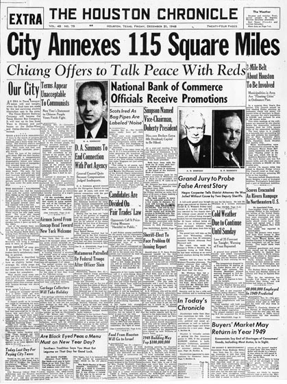
The Houston Chronicle, December 31, 1948. © Houston Chronicle. Used by permission.
City council waited until New Year’s Eve to drop this bombshell. The Houston Chronicle responded with a banner headline. Pasadena and other neighboring cities were not thrilled by the news. Their New Year’s hangover was beginning early and would continue for decades more.